Loading...


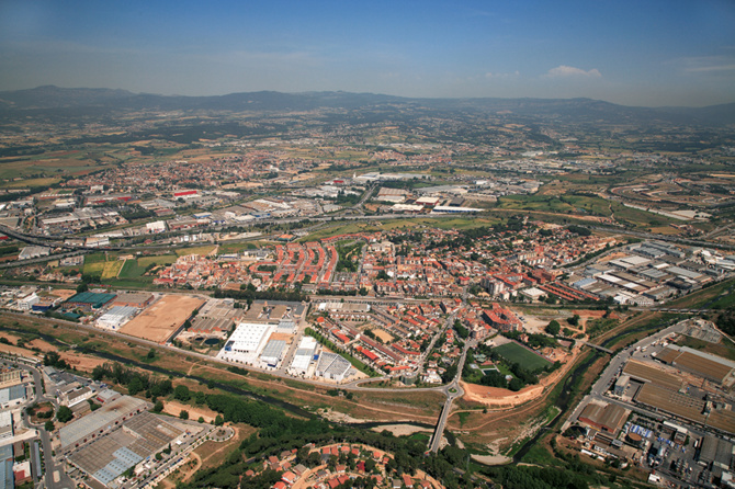
The specificities of the municipality of Montmeló, with a small municipal area (400 Ha) and a territorial context of high density and complexity of territorial infrastructures, shape its urban development potential. From an isolated and physically divided area, in which there are hardly any unoccupied free spaces and whose existing urban land is highly fragmented and unstructured, we can imagine a re-encounter between the city and the environmental territory of the Vallés.
View gallery
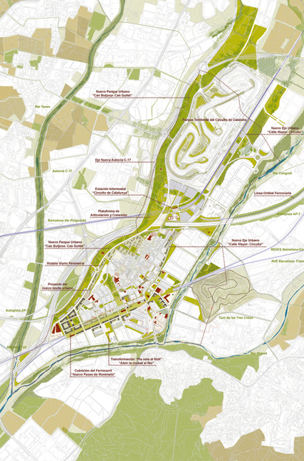
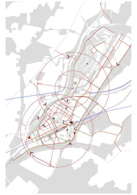
The new plan focuses especially on proposals to reverse the current situation of the municipality, through a renewed reading of its potential, linked to its position as a strategic enclave. Occupying a historical territorial crossroads, and the presence of the Circuit de Catalunya, which should be one of the strategic elements of territorial planning. In this sense, the Plan's proposal establishes a set of actions that represent new challenges of how to intervene in a fragmented and unconnected urban and territorial reality, based on criteria of land optimisation and efficiency of socio-environmental actions: integrating infrastructures, completing and renewing the urban fabric and identifying the strategic nodes of public space.
The Plan bases planning solutions on two simultaneous and complementary actions: re-articulating the territorial mosaic of the geography of rivers and small valleys. Firstly, the city's challenge is to overcome the barriers of the infrastructures that currently divide and isolate the urban nucleus, and to define the design criteria that will guide the implementation of future infrastructures. Actions, which should re-establish multiple and diverse urban and territorial continuities, conceived as catalytic mechanisms of a wider territorial renewal process.
General information
Montmeló Municipal Urban Development Plan
YEAR
Status
Built
Option to visit
Address
08160 Montmelo - Barcelona
Latitude: 41.553164534
Longitude: 2.2475400348
Classification
Built area
Awards
Involved architectural firms
Information provided by
XI BEAU
Location
Click to activate the map
Built
Temporary
Lost
Unbuilt project
https://serviciosdevcarq.gnoss.com/https://serviciosdevcarq.gnoss.com//imagenes/Documentos/imgsem/12/1267/1267e35a-6526-4046-8d76-cdd474be6411/bc94a817-7ef9-477b-af77-35305c4bb426.jpg, 0000037185/20160701143257_11BE-14 1_10.jpg
https://serviciosdevcarq.gnoss.com//imagenes/Documentos/imgsem/12/1267/1267e35a-6526-4046-8d76-cdd474be6411/2d7c24dc-d9e6-4ad3-bbc6-16476adf33aa.jpg, 0000037185/20160701143257_11BE-14 30.jpg
https://serviciosdevcarq.gnoss.com//imagenes/Documentos/imgsem/12/1267/1267e35a-6526-4046-8d76-cdd474be6411/87dfce7c-aaa7-4d19-88c3-ea6a799b4421.jpg, 0000037185/20160701143257_11BE-14 50.jpg
https://serviciosdevcarq.gnoss.com//imagenes/Documentos/imgsem/12/1267/1267e35a-6526-4046-8d76-cdd474be6411/c85cd075-82fb-4fd5-aad7-2ab15a8069f2.jpg, 0000037185/20160701143257_11BE-14 70.jpg

Schedule
Tuesday to Saturday: from 11 to 20 h.
Sundays and holidays: from 11 to 15 h.
La Arquería de Nuevos Ministerios
Paseo de la Castellana, 67
28046 Madrid - España


Horario
Martes a sábado: de 11 a 20 h.
Domingos y festivos: de 11 a 15 h.
La Arquería de Nuevos Ministerios
Paseo de la Castellana, 67
28046 Madrid - España
Design

Powered by

Copyright © 2024. All rights reserved.