Loading...

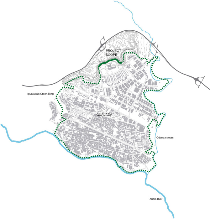
The proposal is set within the broader scheme of the Igualada Green Ring, the aim of which is to generate a series of itineraries for pedestrians and bicycles in the form of a green belt around the city perimeter.
View gallery
This new sustainable mobility infrastructure is designed to provide a system of peri-urban parks and open spaces that function as a network, suitable for environmentally friendly leisure activities, adapting and recovering many spaces that are currently decaying and underused. In this context, the Guixeres path requires the adaptation of a stretch of 1.65km, the first 800m of which have been executed.
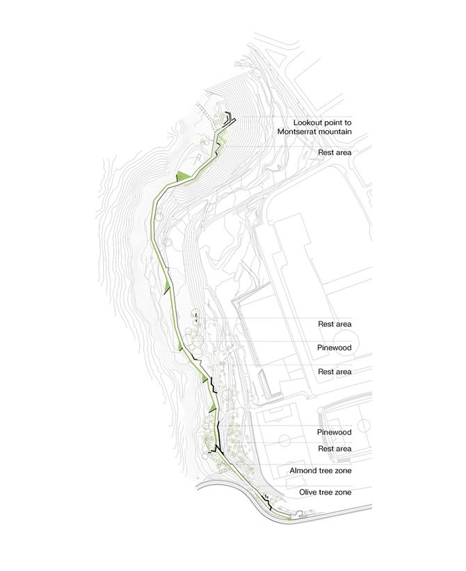
The project has two main objectives: firstly, connectivity, to ensure the continuity of the overall city-scale project (Green Ring) and secondly, landscape recovery and biodiversity, establishing the necessary elements to generate a new dynamic in the place that will gradually improve its environmental conditions by harnessing the stormwater. To achieve this, the proposal consists of the configuration of a standard section with three well-differentiated strips that adapt to the different situations of the route, resolving the problems of the location and, at the same time, developing its potential.
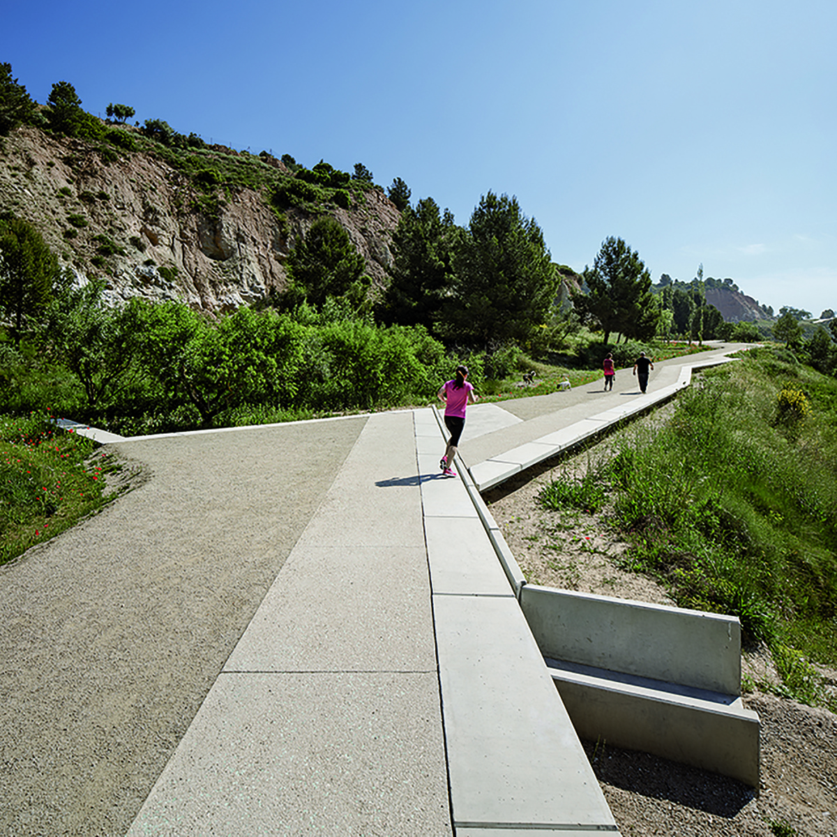
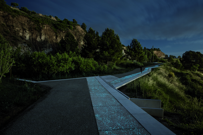
The central strip, the main sandstone path, ensures the continuity of the Green Belt, with an approximate width of 3m, and is arranged in so as to maintain the previous layout of the area. There is also a second strip that forms a linear viewpoint over the city of Igualada. This viewpoint consists of a 1.2m wide paved strip on the outer edge of the path and which direct access to the views. This paved area gives the road a more accessible strip. Furthermore, the concrete has a fraction of luminescent aggregate that improves visibility in the early hours of the night, glowing with the solar energy captured during the day.
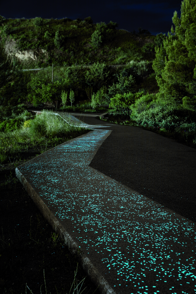
The layout of this linear viewpoint accounts for the main views, the vegetation and the existing trees by including wider spaces and seating areas with linear benches. Finally, this strip gives access to exceptional views over Montserrat from the Guixeres Hill by creating a final viewpoint in the form of a structure overhanging the slope of the mountain.
General information
Recovery of the viewpoint path of the old gypsum mines in Igualada
YEAR
Status
Built
Option to visit
Address
St. de Carles de Riba, 65
08700 Igualada - Barcelona
Latitude: 41.594413023
Longitude: 1.6182717765
Classification
Civil
Built area
Collaborators
Involved architectural firms
Information provided by
batlleiroig
XV BEAU
Location
Click to activate the map
Built
Temporary
Lost
Unbuilt project

https://serviciosdevcarq.gnoss.com/https://serviciosdevcarq.gnoss.com//imagenes/Documentos/imgsem/bb/bb66/bb66d4de-d6b3-4718-a656-8d143f46a100/4cd68354-41fe-4e12-88bf-da8b8425cafa.jpg, 0000004849/1.jpg
https://serviciosdevcarq.gnoss.com/https://serviciosdevcarq.gnoss.com//imagenes/Documentos/imgsem/bb/bb66/bb66d4de-d6b3-4718-a656-8d143f46a100/d22d837e-873f-430a-ba06-d0d19ec5d105.jpg, 0000004849/2.jpg
https://serviciosdevcarq.gnoss.com/https://serviciosdevcarq.gnoss.com//imagenes/Documentos/imgsem/bb/bb66/bb66d4de-d6b3-4718-a656-8d143f46a100/bccb1061-5df9-488e-a982-fb9d8fa60119.jpg, 0000004849/3.jpg
https://serviciosdevcarq.gnoss.com//imagenes/Documentos/imgsem/bb/bb66/bb66d4de-d6b3-4718-a656-8d143f46a100/69919c42-8972-4efc-aa6f-58813494fb35.jpg, 0000004849/823_01 ambito.jpg
https://serviciosdevcarq.gnoss.com//imagenes/Documentos/imgsem/bb/bb66/bb66d4de-d6b3-4718-a656-8d143f46a100/361a6f73-105f-4f4d-9626-d4cb8f812e85.jpg, 0000004849/823_02 ambito.jpg
https://serviciosdevcarq.gnoss.com//imagenes/Documentos/imgsem/bb/bb66/bb66d4de-d6b3-4718-a656-8d143f46a100/b2a1f567-5090-4669-a297-551fa2b08389.jpg, 0000004849/823_03_isometrico.jpg
https://serviciosdevcarq.gnoss.com//imagenes/Documentos/imgsem/bb/bb66/bb66d4de-d6b3-4718-a656-8d143f46a100/e275fbb9-ba5b-48fd-a4ad-07bd46c0f8bf.jpg, 0000004849/823_04_seccio_guixeres.jpg

Schedule
Tuesday to Saturday: from 11 to 20 h.
Sundays and holidays: from 11 to 15 h.
La Arquería de Nuevos Ministerios
Paseo de la Castellana, 67
28046 Madrid - España


Horario
Martes a sábado: de 11 a 20 h.
Domingos y festivos: de 11 a 15 h.
La Arquería de Nuevos Ministerios
Paseo de la Castellana, 67
28046 Madrid - España
Design

Powered by

Copyright © 2024. All rights reserved.