Loading...


The historic centre of Santiago de Compostela was declared a World Heritage Site in 1985. Since then, the City Council has been promoting the rehabilitation, both public and private, of housing and public buildings and, in recent years, of urban space.
View gallery

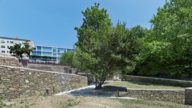
But even so, there are still black holes in the city; degraded environments, with no clear use or easy access. Caramoniña is one such place. On the one hand, it is located in the green belt that surrounds the old town to the east. On the other, in the small street that connects this quarter with the Almaciga neighbourhood, located on another of the small hills that make up the city. The width of the aforementioned alley, together with a difference in level of more than twenty metres - currently resolved by independent terraces - limits access and, consequently, its use.
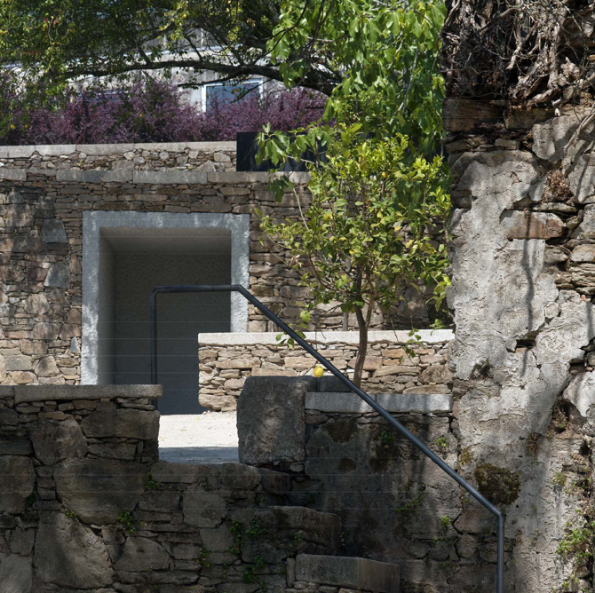
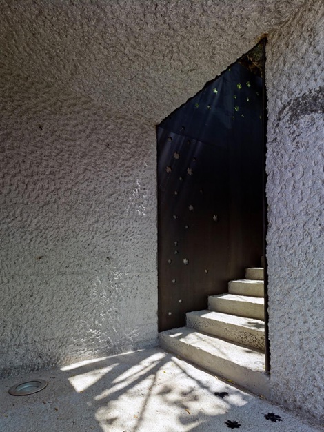
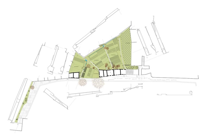
The first action concerns the resolution of accessibility problems between the different levels. When the slope allows it, communication is resolved with ramps inside the plot. And when this is not possible, it is raised directly from the outside, as in the intermediate platform. This provides a series of routes and areas for living and socialising between terraces, with splendid views of the historic city and a good south-west orientation. A shorter route, with stairs, skirts the existing ruins.
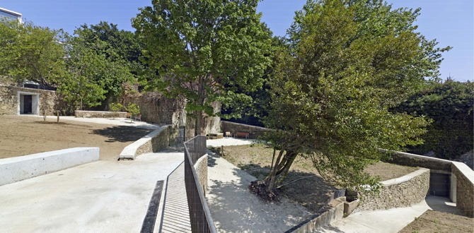
The previous use is recovered through the insertion of a series of vegetable gardens. After all, like a sports field or a health centre, the urban vegetable garden has become just one more public amenity. To support this activity, abandoned wells are renovated and connected to a surface channel.
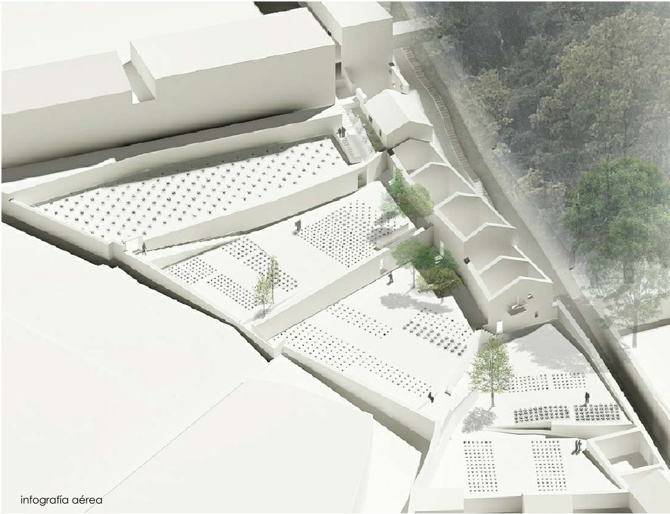
The intervention is completed with lighting that is somewhat reminiscent of the campus stellae that some see as the origin of the urban designation. It is hoped that in the near future the possibility will arise to convert the ruins into a greenhouse, toilets and tool store.
General information
Orchards in Caramoniña
YEAR
Status
Built
Option to visit
Address
St. Caramoniña, s/n
15703 Santiago de Compostela - A Coruña
Latitude: 42.884192705
Longitude: -8.53885843
Building materials
Built area
Involved architectural firms
Information provided by
XIII BEAU
Website links
-
Héctor Santos Díez -

abalo alonso arquitectos
Location
Click to activate the map
Built
Temporary
Lost
Unbuilt project
https://serviciosdevcarq.gnoss.com/https://serviciosdevcarq.gnoss.com//imagenes/Documentos/imgsem/bc/bca6/bca69622-92de-40c1-97c7-164d21655065/40e003fb-583e-4e42-86f0-a83e560b84b2.jpg, 0000006452/huertasrepres.jpg
https://serviciosdevcarq.gnoss.com/https://serviciosdevcarq.gnoss.com//imagenes/Documentos/imgsem/bc/bca6/bca69622-92de-40c1-97c7-164d21655065/10564381-1e29-40be-bd05-86bc0d5ff66a.jpg, 0000006452/huertas2.jpg
https://serviciosdevcarq.gnoss.com/https://serviciosdevcarq.gnoss.com//imagenes/Documentos/imgsem/bc/bca6/bca69622-92de-40c1-97c7-164d21655065/0aee3f4d-b4af-423c-adbb-94c3bdccf2ce.jpg, 0000006452/3.jpg
https://serviciosdevcarq.gnoss.com/https://serviciosdevcarq.gnoss.com//imagenes/Documentos/imgsem/bc/bca6/bca69622-92de-40c1-97c7-164d21655065/7d34375c-dbba-4f15-8805-a820c932d377.jpg, 0000006452/20160226144541_ALO0240_01.jpg
https://serviciosdevcarq.gnoss.com//imagenes/Documentos/imgsem/bc/bca6/bca69622-92de-40c1-97c7-164d21655065/2543a2ec-883f-474e-bb2b-78b88318b342.jpg, 0000006452/Planta.jpg
https://serviciosdevcarq.gnoss.com//imagenes/Documentos/imgsem/bc/bca6/bca69622-92de-40c1-97c7-164d21655065/4b57e13f-4b3c-4819-81d8-306e30fa32d6.jpg, 0000006452/20160226144541_ALO0240_02.jpg

Schedule
Tuesday to Saturday: from 11 to 20 h.
Sundays and holidays: from 11 to 15 h.
La Arquería de Nuevos Ministerios
Paseo de la Castellana, 67
28046 Madrid - España


Horario
Martes a sábado: de 11 a 20 h.
Domingos y festivos: de 11 a 15 h.
La Arquería de Nuevos Ministerios
Paseo de la Castellana, 67
28046 Madrid - España
Design

Powered by

Copyright © 2024. All rights reserved.