Loading...

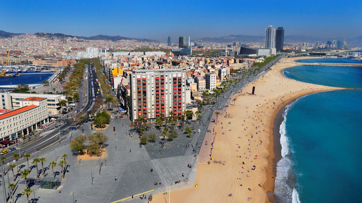
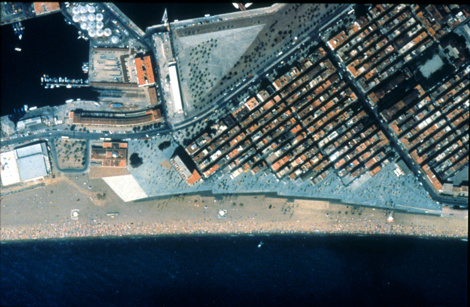
The Barceloneta Waterfront Promenade is the first phase of the continuous system of promenades along the Barceloneta seafront, developed in five phases from the Olympic Port to the Hotel Vela, with a length of 2,200 m.
View gallery

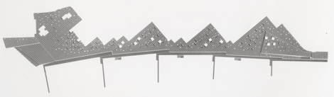
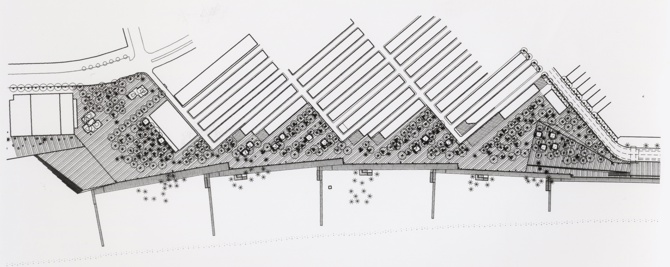
The first phase covers 550 m between Plaza del Mar and Pepe Rubianes street, integrated in the waterfront façade of the Barceloneta neighbourhood, running alongside the neighbourhood streets with a façade of oblique volumes of diverse triangular spaces, creating a promenade that is the sum of the squares integrated in a continuous space.
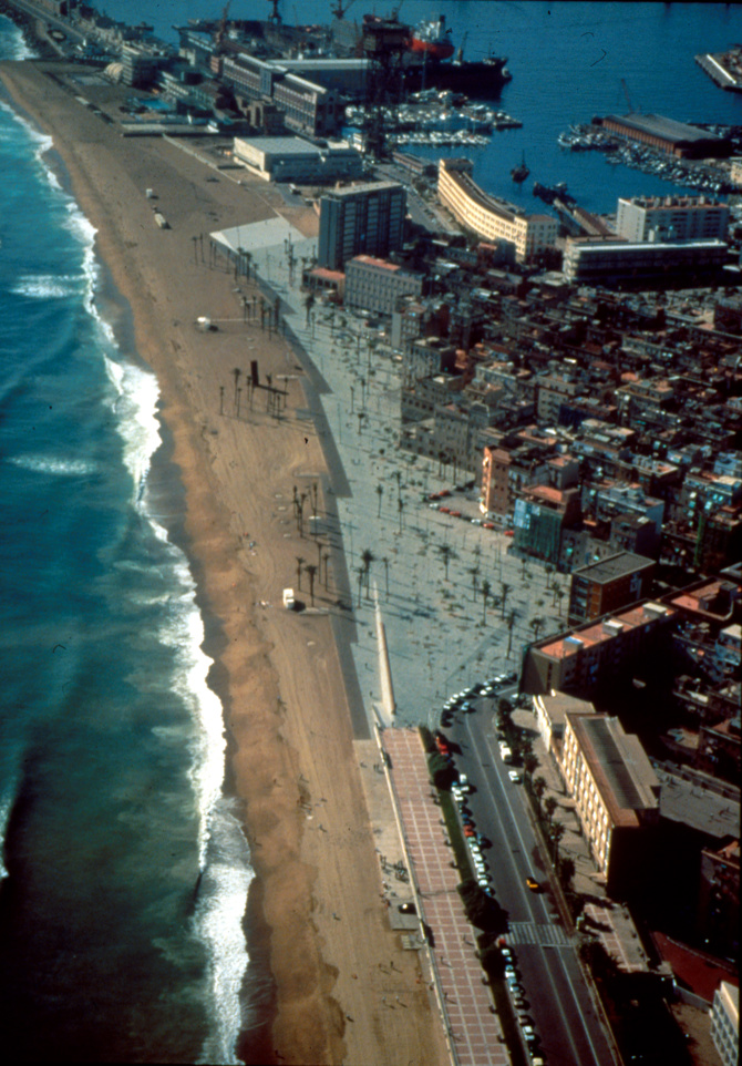
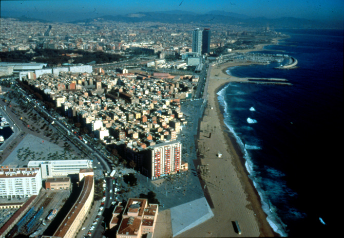
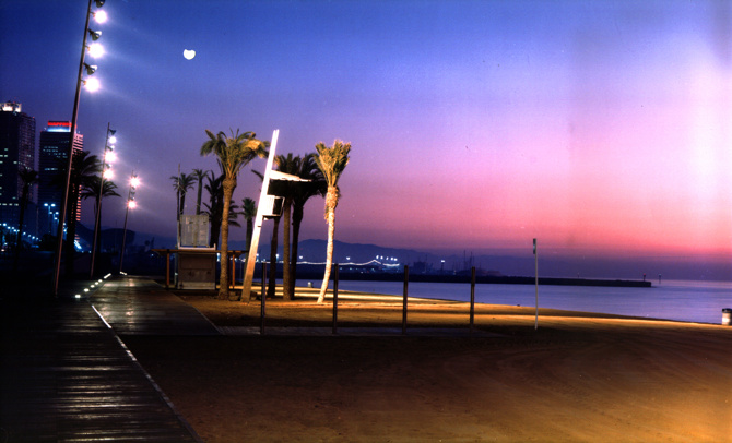
Therefore, the Waterfront Promenade has the dual purpose of a promenade integrated in the neighbourhood, and that of a continuous promenade that integrates the neighbourhood with the beach as a public space, the sea, the horizon, the sky... The tree system is an irregular plantation of various palms, ombus, mulberry trees, tamarinds. The beach is lit by tall columns that lean like large fishing rods that illuminate the beach to integrate it as a public space, creating a subtle and diaphanous order.
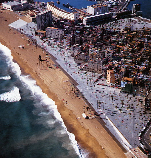
The result is that the Paseo Marítimo and Barceloneta beach form a public space and landscape that give the city its identity and are one of its iconic images.
General information
Remodelling of Barcelona's Promenade
YEAR
Status
Built
Option to visit
Address
Wwy. Marítimo de la Barceloneta, s/n
08003 Barcelona - Barcelona
Latitude: 41.377749312
Longitude: 2.1913022369
Classification
Civil
Construction system
The walkable area is made with concrete bases and Alta slate paving. The contact with the sand with bolondo wood structure on pilotage and autoclave-treated pine decking.
Built area
Involved architects
Website links
-
Barceloneta Promenade - Barcelona City Council -

Barceloneta Promenade - Barcelona City Council -
Aerial view 1 - Barcelona City Council
Location
Click to activate the map
Built
Temporary
Lost
Unbuilt project

https://serviciosdevcarq.gnoss.com/https://serviciosdevcarq.gnoss.com//imagenes/Documentos/imgsem/e8/e81d/e81d687d-ab82-4fc8-aa51-37e72bb97e21/181d797d-2a0d-4168-84a4-14dcdf09f0d4.png, 0000014222/Imagen1.png
https://serviciosdevcarq.gnoss.com/https://serviciosdevcarq.gnoss.com//imagenes/Documentos/imgsem/e8/e81d/e81d687d-ab82-4fc8-aa51-37e72bb97e21/a06d3f6b-29e9-4cd0-b999-943aa64aa43c.jpg, 0000014222/01 .jpg
https://serviciosdevcarq.gnoss.com/https://serviciosdevcarq.gnoss.com//imagenes/Documentos/imgsem/e8/e81d/e81d687d-ab82-4fc8-aa51-37e72bb97e21/5ef5f68b-763e-4b00-9727-e500fb03aa80.jpg, 0000014222/02 .jpg
https://serviciosdevcarq.gnoss.com/https://serviciosdevcarq.gnoss.com//imagenes/Documentos/imgsem/e8/e81d/e81d687d-ab82-4fc8-aa51-37e72bb97e21/08a00521-5ad2-4c13-b1c0-573fa70cd29c.jpg, 0000014222/03 .jpg
https://serviciosdevcarq.gnoss.com/https://serviciosdevcarq.gnoss.com//imagenes/Documentos/imgsem/e8/e81d/e81d687d-ab82-4fc8-aa51-37e72bb97e21/32313f8a-f996-44fa-a023-9da988795dba.jpg, 0000014222/File0012.jpg
https://serviciosdevcarq.gnoss.com/https://serviciosdevcarq.gnoss.com//imagenes/Documentos/imgsem/e8/e81d/e81d687d-ab82-4fc8-aa51-37e72bb97e21/26a8d3ea-bd0f-4cb9-973c-f7e77307bb88.jpg, 0000014222/04 .jpg
https://serviciosdevcarq.gnoss.com/https://serviciosdevcarq.gnoss.com//imagenes/Documentos/imgsem/e8/e81d/e81d687d-ab82-4fc8-aa51-37e72bb97e21/738e62ef-c9c1-4f36-90e1-e4b2941d9387.jpg, 0000014222/Foto 3.jpg
https://serviciosdevcarq.gnoss.com/https://serviciosdevcarq.gnoss.com//imagenes/Documentos/imgsem/e8/e81d/e81d687d-ab82-4fc8-aa51-37e72bb97e21/091393f0-81ed-4e03-89ef-e8192133c6ae.jpg, 0000014222/File0015.jpg
https://serviciosdevcarq.gnoss.com/https://serviciosdevcarq.gnoss.com//imagenes/Documentos/imgsem/e8/e81d/e81d687d-ab82-4fc8-aa51-37e72bb97e21/7aff574b-e1bb-4bb7-a167-f2ebaaa8b1d0.jpg, 0000014222/File0014.jpg
https://serviciosdevcarq.gnoss.com/https://serviciosdevcarq.gnoss.com//imagenes/Documentos/imgsem/e8/e81d/e81d687d-ab82-4fc8-aa51-37e72bb97e21/0a6219e9-6ac2-4eef-9317-0fd9a9776298.jpg, 0000014222/File0013.jpg
https://serviciosdevcarq.gnoss.com//imagenes/Documentos/imgsem/e8/e81d/e81d687d-ab82-4fc8-aa51-37e72bb97e21/7830da44-f252-4ea5-ac8a-346ab057abf5.jpg, 0000014222/Pim0002.jpg
https://serviciosdevcarq.gnoss.com//imagenes/Documentos/imgsem/e8/e81d/e81d687d-ab82-4fc8-aa51-37e72bb97e21/0fa0ae48-eca8-4ac6-a9f7-89e79e68c56d.jpg, 0000014222/Pim0001.jpg
https://serviciosdevcarq.gnoss.com//imagenes/Documentos/imgsem/e8/e81d/e81d687d-ab82-4fc8-aa51-37e72bb97e21/eededcf1-5f0f-46cc-b0da-c0b416e49b58.jpg, 0000014222/Pim0003.jpg

Schedule
Tuesday to Saturday: from 11 to 20 h.
Sundays and holidays: from 11 to 15 h.
La Arquería de Nuevos Ministerios
Paseo de la Castellana, 67
28046 Madrid - España


Horario
Martes a sábado: de 11 a 20 h.
Domingos y festivos: de 11 a 15 h.
La Arquería de Nuevos Ministerios
Paseo de la Castellana, 67
28046 Madrid - España
Design

Powered by

Copyright © 2024. All rights reserved.